If you are an adventure seeker, you would love trekking in Vietnam, well-known for its beautiful mountain peaks and diverse forest wildlife.
Here are five of the country’s top trekking trails.
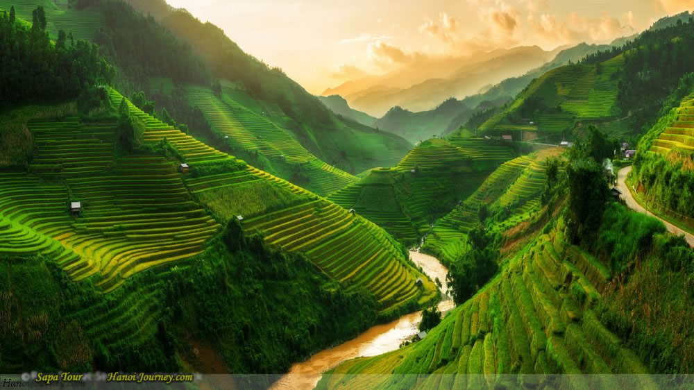
Ta Lien Son
 |
|
Azalea flowers on Ta Lien Son mountain in Lai Chau Province, April 2019. Photo by VnExpress/Quoc Tuan. |
Ta Lien Son lies in Ta Leng Commune, Tam Duong District, Lai Chau Province in northern Vietnam. With an altitude of 2,996 m, it is the highest pinnacle in the mountainous province.
Ta Lien Son boasts a primeval forest and diverse vegetation, with giant overhanging trees covered by ferns and green moss clinging to large rocks in all kinds of shapes.
Each season here brings its own color. Besides the green grass carpet and bamboo forest, at the end of September – November, the forest is dyed in the yellowish-red of maple leaves. In spring, from March to April, it becomes more alluring with a pink Azalea flower coat. At times, you will find yourself walking on a path of white fallen camellia with a sweet, mellow scent.
Reaching the top, Lai Chau Town hidden at the foot of the mountain can be observed, along with the Hoang Lien Son range, Bach Moc Luong Tu peak, and Nhiu Co San Mountain immersed in a sea of clouds.
The journey normally takes three days and two nights to complete, and the best time to trek is between October and November, when the whole maple forest changes color from green to yellowish-red; or March to April, when flowers bloom.
Fansipan
 |
|
Fansipan, the “Roof of Indochina”, in Lao Cai Province. Photo by VnExpress/Ngan Duong. |
Part of the towering Hoang Lien Son mountain range in northern Lao Cai Province, it is the highest mountain in Vietnam and named the “Roof of Indochina”.
As the highest peak, 3,143 m above sea level, this trail offers many spectacular sceneries and diverse vegetation. You will be visiting villages of ethnic minority groups in Sa Pa, passing through dense cane and bamboo forests and discovering the diversified system of flora and fauna listed among Vietnam’s most valuable and rare species.
From March to April, the mountain is coated by many colorful shades of Azalea blossoms including yellow, white, pink, red, and purple. The flowers are considered “queen of the mountainous northwest”.
November is also an ideal time to visit, when the weather is most cool and pleasant, the sky is clear, with no rain. You will have the opportunity to enjoy the view of vast and diffused seas of clouds from the top.
Out of the trekking trails in the list, Fansipan is probably the most difficult and dangerous, and not suitable for amateurs. It requires climbers to be well prepared both physically and mentally because of its steep, slippery and craggy cliffs as well as its extremely narrow paths. In addition, it hosts a lot of insects, snakes, and centipedes. The higher you climb, the wetter the air and the ground become, and the stronger the wind.
There are three routes to conquer Fansipan, with the easiest taking 2-3 days, while the most difficult and dangerous takes up to 4-5 days. You should avoid hiking from June to September, as this is the rainy season, making the wet and slippery path very dangerous.
Lao Than
 |
|
Lao Than Mountain in Lao Cai Province. Photo by Hachi 8. |
Lao Than Mountain, called “Land of Clouds”, is considered the roof of Y Ty Commune in northern Lao Cai Province at an altitude of 2,860 m.
Although this is a newly discovered destination, Lao Than has become one of the most popular trekking spots in the bucket list of adventurers for its beautiful, vast and airy landscapes, and stunning blend of clouds and mountains. Unlike Fansipan, which requires lots of time and energy, anyone can set foot on this peak after a journey of two days and one night.
Lao Than is believed to be the place to watch the first sunrise and the last sunset in Y Ty. You will have the opportunity feel the very first rays of sunlight among spectacular views over the wide mountainous landscape. At times, you are able to enjoy the milky way.
This journey is 16 km long. The trekking path is not too complicated, mainly passing through grassy hills. However, the way to the top is full of bushes and thorns, so it is difficult to move and the wind is quite strong. There are trails but many turns, so you should hire a guide to avoid getting lost. Conquering Lao Than Mountain is considered the first step for trekking enthusiasts to conquer higher peaks.
Lung Cung
 |
|
Trekkers conquer Lung Cung Mountain in Yen Bai Province. Photo acquired by VnExpress. |
Lung Cung Mountain is named after a village located deep inside the most arduous mountains of Nam Co Commune, Mu Cang Chai District, Yen Bai Province in northern Vietnam. There are three routes to reach the top and descend the mountain, all requiring two days and one night to complete.
At the height of 2,913m, the top of Lung Cung is covered in clouds all year round. On the way to the summit, you are able to visit many beautiful destinations like Khau Pha Pass, Che Cu Nha Commune or Ta Co Y Valley.
The diverse and enchanting landscape here is worth the arduous climb. You will be passing through vast, windy and grassy hills, and ancient forests.
The ideal time to conquer Lung Cung is from early autumn to the end of spring.
In September-October, Lung Cung puts on a yellow coat of rice waves swaying in the autumn breeze, mixed with the white of camellia blossoms. In November-December, it is dyed yellow by blooming wild sunflowers, adorned by the purple flower fields in Ta Co Y Valley.
On spring days from January to April, Lung Cung is covered in white plum flowers and pink cherry blossoms. March – April is the ideal time for those who want to hunt clouds.
Ta Nang – Phan Dung
 |
|
Ta Nang – Phan Dung is considered the most beautiful trekking route in Vietnam. Photo by Tuan Anh Tran. |
With a length of more than 50 km, crossing over three provinces of Lam Dong, Ninh Thuan and Binh Thuan, Ta Nang – Phan Dung is believed to be the most beautiful trekking route in Vietnam.
The start of this journey commences from Ta Nang Commune, Duc Trong District, Lam Dong Province in the Central Highlands, which is about 60 km south of Da Lat. The destination lies in Phan Dung Commune, Tuy Phong District in the south-central province of Binh Thuan.
There are two main seasons along this route: green grass (rainy) and yellow grass (dry). Green grass season starts from June to December with sudden rains, coating the hills and pine forests in immense green. Yellow grass season is from December to June with a dry climate during the day and chilly winds at night, changing the scenery into a red-orange shade of burning grass. You will have the opportunity to visit Yaly Waterfall and enjoy camping under the star-lit sky.
Ta Nang – Phan Dung is unlike any other routes with a diverse transition in terms of topography and climate, since Ta Nang lies in Lam Dong and Phan Dung in Binh Thuan. If Ta Nang has a cool climate like Da Lat with beautiful roads and open grasslands, then in Phan Dung the climate is a bit dry and hot like Phan Thiet with winding roads, high slopes up to 1,800 m above sea level, and many pine trees.
This trekking route is also considered one of the most difficult. You will be passing forests and streams, climbing passes containing many steep rocky slopes, moving from a height of 1,100 m down to 500 m above sea level.
It takes 2-3 days to conquer this trail, depending on which route you choose to take, or even 4-5 days if you get tired or lost. Hiring local guides would help make the trip easier and safer.